《Table 2 FCLU mapping of 1975 and 2010》
 提示:宽带有限、当前游客访问压缩模式
本系列图表出处文件名:随高清版一同展现
《Assessing land transformation and associated degradation of the Indian Ganga River Basin using forest cover land use mapping and residual trend analysis》
Note:Types merged for easy comparison.
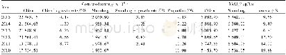
The total area under different vegetation cover(including forest)in the region estimated in both the maps was 19.48%and 19.03%for 1975 and 2010,respectively(Table 2).We mapped 29 forest types covering an area of 1.28×10⁵ km2 in 1975 map and 1.20×10⁵ km2 in 2010 map(Fig.3).The deciduous forest was not only mapped as the major forest cover in the basin but also showed the highest forest loss(4397 km2)during 1975 and 2010.An increase in the forest plantation(1557km2)and degraded forest cover(580 km2)was mapped in the Northern Terai.Agricultural land of the Central Gangetic Plain was also found encompassed by orchard plantation and invasion of Prosopis scrub in 2010 map.In non-vegetation cover types,the settlement was mapped showing the highest increase of 5396 km2,followed by barren(212.86 km2),while water body and wetland cover types were also observed to be reduced over time(Table 2).
| 图表编号 | XD0031565200 严禁用于非法目的 |
|---|---|
| 绘制时间 | 2019.02.01 |
| 作者 | Shafique MATIN、Sujit GHOSH、Mukunda D BEHERA |
| 绘制单位 | Centre for Oceans, Rivers, Atmosphere and Land Sciences, Indian Institute of Technology Kharagpur、Centre for Oceans, Rivers, Atmosphere and Land Sciences, Indian Institute of Technology Kharagpur、Centre for Oceans, Rivers, Atmosphere and Land Sciences, In |
| 更多格式 | 高清、无水印(增值服务) |

