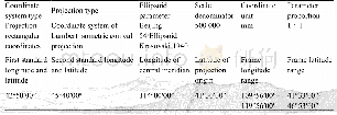
《Table 2 Parameters of the geological map spatial database of the Xiwuqi and Bainaimiao areas in the
 提示:宽带有限、当前游客访问压缩模式
本系列图表出处文件名:随高清版一同展现
《1:500000二连–东乌旗成矿带西乌旗和白乃庙地区地质图空间数据库》
(2) In terms of data processing,firstly,the spatial information of all source data used for mapping is checked for accuracy,and data that had a spatial position which deviated or were lost were then revised to the correct position with a standard map frame;secondly,following dovetailing of projected maps,geobodies that failed to dovetail as a result of inconsistencies in certain 1∶50 000 and 1∶250 000 geological maps completed by different teams were verified in field work.In addition,in terms of data processing,the team carried out 100%self-checks and mutual checks on the processed data,especially the manually input attribute table,and modified the database after being checked and accepted by experts.The above measures ensure the quality of the database regarding source data and processing.
| 图表编号 | XD00219947000 严禁用于非法目的 |
|---|---|
| 绘制时间 | 2020.06.01 |
| 作者 | 王树庆、胡晓佳、杨泽黎、刘永顺、刘洋、王文龙、郭硕、何鹏、滕飞 |
| 绘制单位 | 中国地质调查局天津地质调查中心、华北地质科技创新中心、中国地质调查局天津地质调查中心、华北地质科技创新中心、中国地质调查局天津地质调查中心、华北地质科技创新中心、中国地质调查局天津地质调查中心、华北地质科技创新中心、中国地质调查局天津地质调查中心、华北地质科技创新中心、中国地质调查局天津地质调查中心、华北地质科技创新中心、中国地质调查局天津地质调查中心、华北地质科技创新中心、中国地质调查局天津地质调查中心、华北地质科技创新中心、中国地质调查局天津地质调查中心、华北地质科技创新中心 |
| 更多格式 | 高清、无水印(增值服务) |