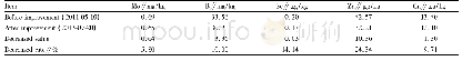
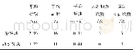
《Table 3 P-values of the accuracy improvement of the soil map updated with the proposed method and w
 提示:宽带有限、当前游客访问压缩模式
本系列图表出处文件名:随高清版一同展现
《Updating conventional soil maps by mining soil–environment relationships from individual soil polygons》
*and**indicate the accuracy improvement is statistically significant at the 0.05 and 0.01 level,respectively.
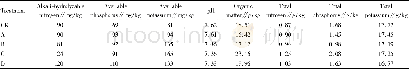
Next,the step functions of the relationships between map units and their corresponding parent materials were constructed as described in Section 2.3.And the decomposed step function between a complex map unit and each of its corresponding parent material was also constructed.The result is 17 pairs of map unit–parent material(i.e.,step functions)(Table 1;Fig.8) .The area covered by these 17 pairs of map unit–parent material accounts for 88.9%of the total area.The rest area contains either border polygons or combinations between soils and parent materials that are not typical for the soils and thus considered to be unreasonable and excluded from the steps below.
| 图表编号 | XD0047429800 严禁用于非法目的 |
|---|---|
| 绘制时间 | 2019.02.20 |
| 作者 | CHENG Wei、ZHU A-xing、QIN Cheng-zhi、QI Feng |
| 绘制单位 | State Key Laboratory of Resources and Environmental Information System, Institute of Geographic Sciences and Natural Resources Research, Chinese Academy of Sciences、University of Chinese Academy of Sciences、State Key Laboratory of Resources and Environmen |
| 更多格式 | 高清、无水印(增值服务) |
