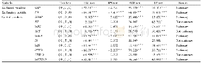
《Table 4 Mapping units of the intrusions》
 提示:宽带有限、当前游客访问压缩模式
The 1∶50 000 geologic map of the Shimen map sheet,Henan Province is a result map of a new round of geological surveys initiated by China Geological Survey.Detailed geologic mapping was conducted for the map sheet according to the‘Technical Requirements for Regional Geological Survey(Scale:1∶50 000)’based on the systematical collection of previous research data.It has improved the level of regional geological survey and fundamental research,and achieved new breakthroughs in solving major basic geological problems.The main focus of this study is to summarize the types of the intrusions,emplacement eras and tectonic setting in the map sheet.As a result,the previously determined Shimen and Wuduoshan intrusives were incorporated into the four stages of magmatic activities,namely Late Ordovician (465.0–449.1 Ma),Early Silurian (435.7–433.3 Ma),MidLate Silurian and the end of the Silurian period (418.0 Ma)(Table 4).It can be argued that the map sheet underwent Late Cambrian–Middle Ordovician plate subduction,Late Ordovician–Middle Silurian plate collision and the end of the Silurian period–Early Devonian postcollision process (Yang LM et al.,2018;Meng XS et al.,2017;Li KW et al.,2018,2019b).Furthermore,it was put forward that the Nanzhao area in the north Qinling Mountains changed from a subduction environment to a continent-continent collision environment at the end of Early Silurian (Li KW et al.,2019a),which is consistent with the understanding of Chen YW et al.(2018),Li N et al.(2018)and Zhou S et al.(2020).In this study,the eras of the Damiao Formation and Huoshenmiao Formation of the Early Paleozoic Erlangping Group were redetermined to be of Cambrian–Ordovician (Table 5).These findings will provide basic geologic data for further surveys of geology and mineral prospecting in the map sheet,basic maps for follow-up geologic hazard prevention and control,and ecological environmental protection in the map sheet.
| 图表编号 | XD00219953400 严禁用于非法目的 |
|---|---|
| 绘制时间 | 2020.06.01 |
| 作者 | 李开文、方怀宾、晁红丽、刘坤、王小娟 |
| 绘制单位 | 河南省地质调查院、河南省金属矿产成矿地质过程与资源利用重点实验室、河南省地质调查院、河南省地质调查院、河南省地质调查院、河南省地质调查院 |
| 更多格式 | 高清、无水印(增值服务) |

