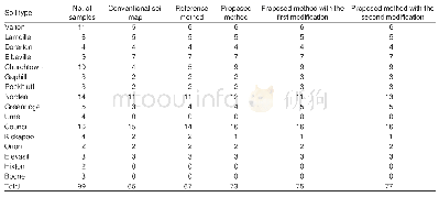
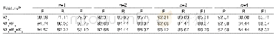
《Table 2 Number of samples for each soil type correctly classified in the conventional soil map and
 提示:宽带有限、当前游客访问压缩模式
本系列图表出处文件名:随高清版一同展现
《Updating conventional soil maps by mining soil–environment relationships from individual soil polygons》
The number of samples correctly classified with the proposed method is six more than that with the reference method(Table 2).Most of the accuracy improvement occurred in the Churchtown map unit,which contains only one soil type and accounts for 13.9%of the total study area.Here,the Churchtown map unit was taken as an example to discuss the performance of the proposed method in more detail.
| 图表编号 | XD0047429700 严禁用于非法目的 |
|---|---|
| 绘制时间 | 2019.02.20 |
| 作者 | CHENG Wei、ZHU A-xing、QIN Cheng-zhi、QI Feng |
| 绘制单位 | State Key Laboratory of Resources and Environmental Information System, Institute of Geographic Sciences and Natural Resources Research, Chinese Academy of Sciences、University of Chinese Academy of Sciences、State Key Laboratory of Resources and Environmen |
| 更多格式 | 高清、无水印(增值服务) |

