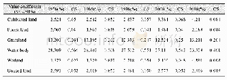
《Table 2 Average runoff coefficient for each ecosystem type》
 提示:宽带有限、当前游客访问压缩模式
本系列图表出处文件名:随高清版一同展现
《Spatial-temporal Patterns and Driving Forces of Water Retention Service in China》
Cartographic and statistical datasets were used in our study,including an ecosystems map,precipitation,temperature,evapotranspiration,digital elevation model,population density and socioeconomic data(county level).Some details concerning the data are listed in Table 1.All cartographic data were converted to the same coordinate system(Albers Conical Equal Area)and same spatial resolution(1000 m).
| 图表编号 | XD0046957700 严禁用于非法目的 |
|---|---|
| 绘制时间 | 2019.02.01 |
| 作者 | XIAO Yang、OUYANG Zhiyun |
| 绘制单位 | State Key Laboratory of Urban and Regional Ecology, Research Center for Eco-Environmental Sciences, Chinese Academy of Sciences、University of Chinese Academy of Sciences、State Key Laboratory of Urban and Regional Ecology, Research Center for Eco-Environme |
| 更多格式 | 高清、无水印(增值服务) |


