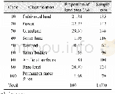
《Table 3 Comparisons between Globe Land30-WTR2010 extraction indexes and topographic map requirement
 提示:宽带有限、当前游客访问压缩模式
本系列图表出处文件名:随高清版一同展现
《全球30m分辨率陆表水域数据集(2010)内容与研发》
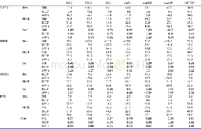
In addition,for the quality control,we keep the water areas smaller than the minimum spot pattern,if it is possible.In light of regional differences in areas of land surface waters when viewed from a global perspective,we also formulated a number of quality control indexes for the extraction of areas of water.
| 图表编号 | XD0027610600 严禁用于非法目的 |
|---|---|
| 绘制时间 | 2017.03.25 |
| 作者 | 陈军、廖安平、陈利军、张宏伟、何超英、彭舒、武昊、张委伟、李然、郑新燕、梅洋、陆苗、鲁楠、康睿、邢华侨、刘丽芬、韩刚、王京、杨爱玲、孙丽梅、宋昊、陈卫平、周晓敏、夏露、蒋红兵、霍健、张艳、刘无敌、李雨鲜、翟亮、桑会勇 |
| 绘制单位 | 国家基础地理信息中心、国家基础地理信息中心、国家基础地理信息中心、国家基础地理信息中心、国家基础地理信息中心、国家基础地理信息中心、国家基础地理信息中心、国家基础地理信息中心、国家基础地理信息中心、国家基础地理信息中心、国家基础地理信息中心、国家基础地理信息中心、国家基础地理信息中心、国家基础地理信息中心、国家基础地理信息中心、国家基础地理信息中心、国信司南(北京)地理信息技术有限公司、国家基础地理信息中心、国信司南(北京)地理信息技术有限公司、国信司南(北京)地理信息技术有限公司、黑龙江基础地理信息中心 |
| 更多格式 | 高清、无水印(增值服务) |

