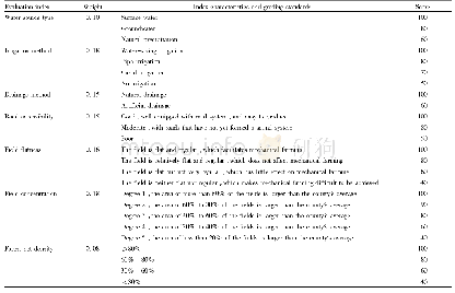
《Table 3 Factor maps, fuzzification method and weighting score used to evaluate the sensitivity of l
 提示:宽带有限、当前游客访问压缩模式
本系列图表出处文件名:随高清版一同展现
《Evaluating and modeling the spatiotemporal pattern of regional-scale salinized land expansion in highly sensitive shoreline landscape of southeastern Iran》
Note:Consistency ratio,5.9%;Number of comparisons,6;MD,monotonically decreasing;c and d denote the first and second fuzzy set breakpoints,respectively.
In this research,four transition probability matrices were built using Markov chain model to estimate the magnitude of salinized land expansion for 2015(by the interpretation of changes from 1986 to 2000 (calibration phase)) ,2030,2040 and 2050(by implementing the 1986 and2015 as the earlier and later LULC maps,respectively (prediction phase)) .Four factors including distance to sea,distance to sea water channels,slope,and elevation were identified as the main driving forces imposing salinized land expansion through the whole extent of the study area.The elevation and distance to sea express the potential effects of saline groundwater of the Oman Sea,which controls the upstream freshwater by extensive dam construction(Moradi,2016).The above two factors substantially represent the effects of groundwater which we were not practically able to map in the regional scale.The sea water channel represents an anthropogenic driving force providing local communities with the opportunity to conduct agricultural activities with saline sea waters.The slope is a general factor expressing the sensitivity of soil affected by large-scale salinization.All factor maps were transformed to a scale-independent range of 0 to 255 where values close to 255 indicate a higher sensitivity of land to salinization using different types of fuzzy membership functions(Table 3).All factors were compared in pairs and the corresponding weights were extracted by taking the analytical hierarchy process method(Saaty,2008;Eastman,2012).The weighted and standardized factor maps were linearly combined by using Equation 1 to produce the final land suitability map.The resulting map of the MCE procedure was referred to land sensitivity map to salinization.
| 图表编号 | XD0020366200 严禁用于非法目的 |
|---|---|
| 绘制时间 | 2018.12.01 |
| 作者 | Mohammad SHAFIEZADEH、Hossein MORADI、Sima FAKHERAN |
| 绘制单位 | Department of Natural Resources, Isfahan University of Technology、Department of Natural Resources, Isfahan University of Technology、Department of Natural Resources, Isfahan University of Technology |
| 更多格式 | 高清、无水印(增值服务) |


