《Table 1 Forest cover land use (FCLU) classification》
 提示:宽带有限、当前游客访问压缩模式
本系列图表出处文件名:随高清版一同展现
《Assessing land transformation and associated degradation of the Indian Ganga River Basin using forest cover land use mapping and residual trend analysis》
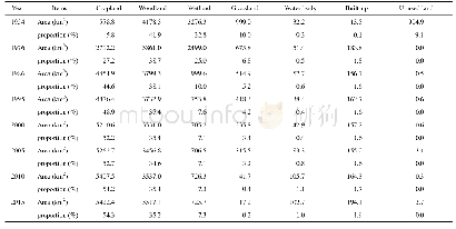
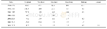
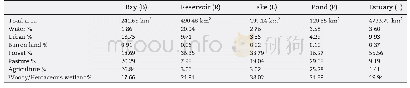
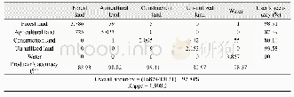
Moderate resolution(30 m)images of Landsat TM sensor were used to prepare the FCLU map of2010 at first and the 1975 FCLU map was generated by editing the 2010 shapefiles utilizing the 60m Landsat MSS images in the backdrop.Visual interpretation technique was applied to classify the entire study area into 47 different types following a pre-existing classification scheme(Table 1).The scheme divides the entire study area into vegetation and non-vegetation types and further into29 forest and 18 non-forest types.The forest types were subdivided into mixed,gregarious,localespecific,degraded/successional formations and plantation.Degraded forest resulted mostly from human interferences,but also by natural succession.A class-wise comparison was carried out to estimate the changes in the area statistics during the period 1975–2010.The mapping accuracy was accessed using 1509 sample plots gathered through field sampling during the biodiversity characterization at landscape level project using a sample size of 20 m×20 m for trees,5 m×5 m for shrubs and 1 m×1 m for herbs(Matin et al.,2012).
| 图表编号 | XD0031565300 严禁用于非法目的 |
|---|---|
| 绘制时间 | 2019.02.01 |
| 作者 | Shafique MATIN、Sujit GHOSH、Mukunda D BEHERA |
| 绘制单位 | Centre for Oceans, Rivers, Atmosphere and Land Sciences, Indian Institute of Technology Kharagpur、Centre for Oceans, Rivers, Atmosphere and Land Sciences, Indian Institute of Technology Kharagpur、Centre for Oceans, Rivers, Atmosphere and Land Sciences, In |
| 更多格式 | 高清、无水印(增值服务) |
