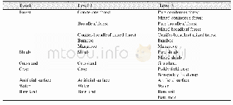
《Table 2 Land cover classification system adopted in remote sensing based mapping on wetlands of int
 提示:宽带有限、当前游客访问压缩模式
本系列图表出处文件名:随高清版一同展现
《大型国际重要湿地边界及遥感分类数据集(2001、2013)》
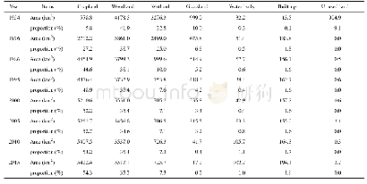
Most of the wetland boundaries were delineated by reference to the scanned paper maps published on the Ramsar website(https://rsis.ramsar.org/.Retrieved on July 23,2014)[6].Another small part of them were derived from World Database on Protected Areas(https://www.iucn.org/;http://www.protectedplanet.net/.Retrieved on July 23,2014)and the other products of literature and document.The maps were georeferenced in ArcGIS.Because there are many differences of wetland management and monitoring techniques in each country,some inconsistencies of the boundaries often occur in such occasion.Therefore we made modification and verification by using high resolution remote sensing images on Google Earth platform,based on the physiographic forms of wetlands such as walking along rivers,roads,and the ridge lines.The MODIS product MOD13Q1(16-day composite,250 m)in 2001 and 2013 downloaded from NASA(https://ladsweb.nascom.nasa.gov/data/)was used as the main data source.There are 23 periods of the images in each year.In this study,the images on the public service platform Tianditu(http://www.tianditu.com/map/index.html)powered by the National Geomatics Center of China(NGCC)and other geographic data were also used as auxiliary data.The Normalized Difference Vegetation Index(NDVI)can reflect the growth status of different vegetation types.By comparing the NDVI differences including the maximum,the minimum,and the range of annual NDVI,the emergence date of the positive NDVI value,and the growing season length,etc.between different vegetation types in the growth cycle or within a calendar year,and analyzing plants growth pattern[7],the accuracy of interpretation on different types of land cover types could be effectively improved.We applied Savitzky-Golay filtering to reconstruct NDVI time series dataset[8].Based on the clustering results of time series data and the analysis on the features of different land cover types in high resolution remote sensing images,we collected 10-20training samples for each type and used SVM classifier to delineate and map different types of wetlands.The minimum of the map unit is about56.25 hm2 for 3×3 pixels.The main methods and the technical flow are described in Figure 2.
| 图表编号 | XD0027619000 严禁用于非法目的 |
|---|---|
| 绘制时间 | 2017.06.29 |
| 作者 | 张海英、牛振国、许盼盼、陈燕芬、胡胜杰、宫宁 |
| 绘制单位 | 中国科学院遥感与数字地球研究所遥感科学国家重点实验室、中国科学院遥感与数字地球研究所遥感科学国家重点实验室、中国科学院遥感与数字地球研究所遥感科学国家重点实验室、中国科学院遥感与数字地球研究所遥感科学国家重点实验室、中国科学院遥感与数字地球研究所遥感科学国家重点实验室、山东农业大学资源与环境学院 |
| 更多格式 | 高清、无水印(增值服务) |