《Table 1 Remote sensing satellite parameters of different sen-sors》
 提示:宽带有限、当前游客访问压缩模式
本系列图表出处文件名:随高清版一同展现
《Comparative Study on Coastal Depth Inversion Based on Multi-source Remote Sensing Data》
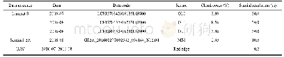
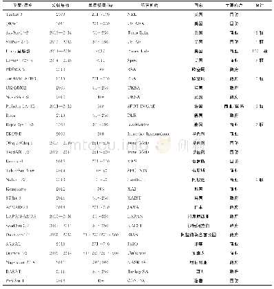
Notes:SPOT-6 is the Systeme Probatoire d’Observation de la Terre,No.6.NIR is the band of near infrared
The study used three types of data,including the United States(US)Landsat-8,the French SPOT-6 and the US WorldView-2 satellite data.The acquisition time,spectral values of the used band,and spatial resolution are listed in Table 1.Water depth-measured data used the single-point sonar data measured by Guangzhou Marine Geological Survey in November 2014.There are multiple measured points in the same pixel due to the fact that the sounding points of the survey line are dense,which will cause the measured points at different depths of the pixel correspond to the digital number(DN)value of the same pixel and result in an increase in inversion error.Therefore,the number of sounding points becomes less in order to avoid increasing the inversion error.The distribution of measured points is shown in Fig.3.Adopted satellite remote sensing data are applied in the fourth quarter of 2013.It can be applied because the image time is close to the measured data collection time.
| 图表编号 | XD0046959900 严禁用于非法目的 |
|---|---|
| 绘制时间 | 2019.04.01 |
| 作者 | LU Tianqi、CHEN Shengbo、TU Yuan、YU Yan、CAO Yijing、JIANG Deyang |
| 绘制单位 | College of Geo-exploration Science and Technology, Jilin University、College of Geo-exploration Science and Technology, Jilin University、College of Earth Sciences,Guilin University of Technology、College of Geo-exploration Science and Technology, Jilin Univ |
| 更多格式 | 高清、无水印(增值服务) |