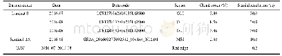
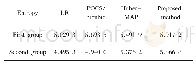
《Table 2 Characteristics of the remote sensing data》
 提示:宽带有限、当前游客访问压缩模式
本系列图表出处文件名:随高清版一同展现
《Comparative Analysis of Fractional Vegetation Cover Estimation Based on Multi-sensor Data in a Semi-arid Sandy Area》
Notes:‘–’represents no data.‘Cloud cover’means the coverage percent of cloud in an image
The S2 multispectral instrument(MSI)data,L8 operational land imager(OLI)data and UAV(Model:EcoDrone UAS-4)red edge sensor data were acquired in study area;Table 1 and Table 2 show the associated information.The flight control system of EcoDrone UAS-4 is composed of aircraft’s control module and ground station,and aircraft’s control module mainly includes CPU(Central Processing Unit),high-precision GPS(Global Position System)and TAS(Three-axis Attitude Sensor).
| 图表编号 | XD0046959400 严禁用于非法目的 |
|---|---|
| 绘制时间 | 2019.02.01 |
| 作者 | LIU Qiuyu、ZHANG Tinglong、LI Yizhe、LI Ying、BU Chongfeng、ZHANG Qingfeng |
| 绘制单位 | College of Natural Resources and Environment, Northwest A&F University、College of Natural Resources and Environment, Northwest A&F University、College of Natural Resources and Environment, Northwest A&F University、College of Natural Resources and Environme |
| 更多格式 | 高清、无水印(增值服务) |
