《表1 卫星遥感影像分辨率对照表Tab.1 Satellite remote sensing image resolution》
 提示:宽带有限、当前游客访问压缩模式
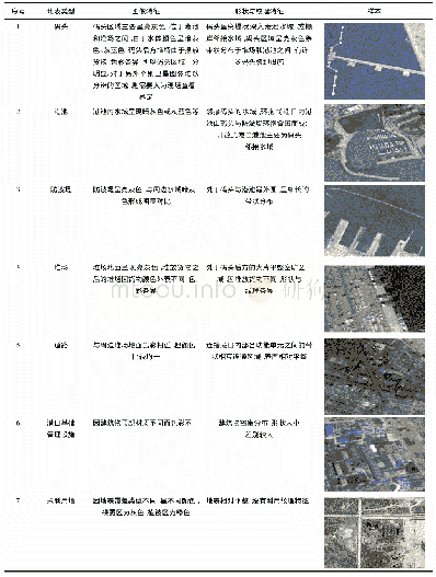
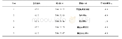
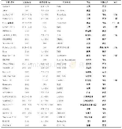
根据我省基础影像数据源的情况,数字正射影像数据的地面分辨率采用0.8 m、1.0 m两种规格。其数字正射影像的分辨率按表1执行。
| 图表编号 | XD0014030100 严禁用于非法目的 |
|---|---|
| 绘制时间 | 2018.09.25 |
| 作者 | 席岩松、袁宗福 |
| 绘制单位 | 吉林省地理信息院、吉林省地理信息院 |
| 更多格式 | 高清、无水印(增值服务) |
根据我省基础影像数据源的情况,数字正射影像数据的地面分辨率采用0.8 m、1.0 m两种规格。其数字正射影像的分辨率按表1执行。
| 图表编号 | XD0014030100 严禁用于非法目的 |
|---|---|
| 绘制时间 | 2018.09.25 |
| 作者 | 席岩松、袁宗福 |
| 绘制单位 | 吉林省地理信息院、吉林省地理信息院 |
| 更多格式 | 高清、无水印(增值服务) |
