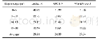
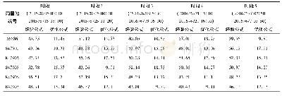
《Table 3 Mean relative error of depth inversion and measured depth (%)》
 提示:宽带有限、当前游客访问压缩模式
本系列图表出处文件名:随高清版一同展现
《Comparative Study on Coastal Depth Inversion Based on Multi-source Remote Sensing Data》
Calculating mean relative error of water depth inversion from remote sensing image in different depth ranges,the results are shown in Table 3.
| 图表编号 | XD0046960000 严禁用于非法目的 |
|---|---|
| 绘制时间 | 2019.04.01 |
| 作者 | LU Tianqi、CHEN Shengbo、TU Yuan、YU Yan、CAO Yijing、JIANG Deyang |
| 绘制单位 | College of Geo-exploration Science and Technology, Jilin University、College of Geo-exploration Science and Technology, Jilin University、College of Earth Sciences,Guilin University of Technology、College of Geo-exploration Science and Technology, Jilin Univ |
| 更多格式 | 高清、无水印(增值服务) |
