《Table 2 Correlation coefficient of different band ratio models for different satellites》
 提示:宽带有限、当前游客访问压缩模式
本系列图表出处文件名:随高清版一同展现
《Comparative Study on Coastal Depth Inversion Based on Multi-source Remote Sensing Data》
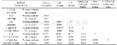
Notes:B,G,R are the abbreviation for the band of blue,green and red,respectively.NIR is the band of near infrared
In this study,we build six band ratio models with blue,green,red,and near-infrared bands.The parameters of the band ratio model are regression analyzed by using the attribute information of measured points of the water depth which includes the reflectance value and water depth of each band of the image.Correlation coefficient is shown in Table 2.It can be seen from table that the correlation coefficient of blue-near-infrared band ratio model of Landsat-8 image is the highest,and R2 is equal to 0.5073;the correlation coefficient of green-red band ratio model of SPOT-6 is the highest,and R2 is equal to 0.7064;the correlation coefficient of blue-green band ratio model of WorldView-2 is the highest,and R2 is equal to 0.6679(Fig.5).Thus,we choose the above models as the final models to inverse the water depth.
| 图表编号 | XD0046960100 严禁用于非法目的 |
|---|---|
| 绘制时间 | 2019.04.01 |
| 作者 | LU Tianqi、CHEN Shengbo、TU Yuan、YU Yan、CAO Yijing、JIANG Deyang |
| 绘制单位 | College of Geo-exploration Science and Technology, Jilin University、College of Geo-exploration Science and Technology, Jilin University、College of Earth Sciences,Guilin University of Technology、College of Geo-exploration Science and Technology, Jilin Univ |
| 更多格式 | 高清、无水印(增值服务) |

