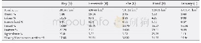
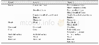
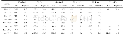
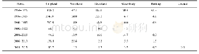
《Table 1–Watershed land use and land cover of the study areas.》
 提示:宽带有限、当前游客访问压缩模式
本系列图表出处文件名:随高清版一同展现
《Effect of photo-biodegradation and biodegradation on the biogeochemical cycling of dissolved organic matter across diverse surface water bodies》
The land use land cover classification of the study areas was evaluated from the geospatial data that was collected from United States Department of Agriculture(USDA)data gateway and later processed in the Arc GIS?10.3.1 software platform(Table 1).The seven major land cover classes surrounding the water bodies were urbanized area,barren land,forest,pasture,agriculture and woody/herbaceous wetland.Among the waterbodies,the estuary(E)was the biggest(170.56 km2,3.60%)and pond(P)was the smallest(4.32 km2,3.58%).The lake(L)was surrounded by forest(67.28 km2,33.79%)and woody herbaceous wetland(75.71 km2,38.02%).The pond(P)was surrounded by pasture(35.09 km2,29.08%)and agricultural area(30.50 km2,25.28%).Predominant land use land cover surrounding the reservoir(R)was forest(178.28 km2,36.35%)and woody herbaceous wetland(107.47 km2,21.91%).The estuary watershed is predominantly covered by forest(2630.17 km2,55.56%)and woody herbaceous wetland(943.81 km2,19.94%).The immediate surrounding of the bay(B)is also covered by forest(45.18 km2,18.69%)and woody herbaceous wetland(42.88 km2,17.66%).
| 图表编号 | XD0033518000 严禁用于非法目的 |
|---|---|
| 绘制时间 | 2019.03.15 |
| 作者 | M.S.Sankar、Padmanava Dash、Shatrughan Singh、YueHan Lu、ANDrew E.Mercer、Shuo Chen |
| 绘制单位 | Department of Geosciences, Mississippi State University、Department of Geosciences, Mississippi State University、Department of Geosciences, Mississippi State University、Department of Geological Sciences, University of Alabama、Academy for Advanced Interdisc |
| 更多格式 | 高清、无水印(增值服务) |