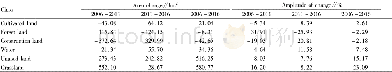
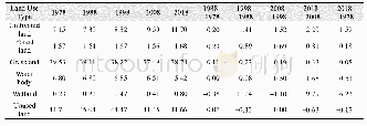
《Table 4 The land use area change and change amplitude of Bole City》
 提示:宽带有限、当前游客访问压缩模式
本系列图表出处文件名:随高清版一同展现
《Analysis of Land Use Change and Driving Force of Bole City Based on Remote Sensing Image》
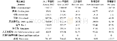
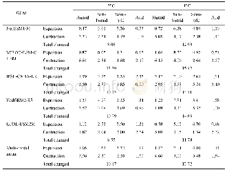
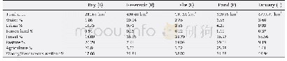
Land classification can be classified into humanistic classification and natural classification,and remote sensing usually solves natural classification[4],the land classification mentioned in this paper refers to natural classification.Because of its special features,remote sensing cannot strictly perform classification according to the requirements of the above land use classification.Therefore,combined with remote sensing images and local geographical features and related maps,we decided to divide the land use types in the study area into cultivated land,forest land,construction land,water,unused land and grassland,and classify the two level classification as shown in Table 2.
| 图表编号 | XD00183097700 严禁用于非法目的 |
|---|---|
| 绘制时间 | 2018.08.01 |
| 作者 | Zuliyaer Kuerban、Maying、Zulifeiya Maiming、Alimujiang Tusiyiti、Silayi |
| 绘制单位 | School of management,Xinjiang Agricultural University、School of management,Xinjiang Agricultural University、School of management,Xinjiang Agricultural University、School of management,Xinjiang Agricultural University、Bole Bole City Land Resources Bureau |
| 更多格式 | 高清、无水印(增值服务) |