《Table 4 Changes in national farmland use classification in project areas after implementation of co
 提示:宽带有限、当前游客访问压缩模式
本系列图表出处文件名:随高清版一同展现
《Site Selection of Land Consolidation Project Based on Farmland Quality Evaluation in Yanjin County of Henan Province》
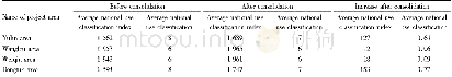
Based on the calculated average national classification index of farmland,the farmland was divided into corresponding national natural classification,national use classification,and national economic classification.Taking the national use classification as an example,we analyzed changes in each project area after the land consolidation projects.The changes in national classification index and average national use classification were listed in Table 4.After the implementation of the consolidation projects,the average national use classification index of all project areas had certain level of increase,Dongtun area and Yulin area had the largest increase(by 153 and 127 respectively),and the corresponding average national use classification increased one level.The comprehensive production conditions(such as drainage conditions and probability of irrigation)of these two areas were worse before consolidation,thus the improvement of farmland production conditions was most effective after consolidation.For Wanglou area and Weiqiu area with excellent field production conditions before consolidation,the consolidation projects had limited improvement effect and mainly played the role of consolidating the original productivity.The average national use classification index showed certain increase,but there was no change in average classification.
| 图表编号 | XD00182594900 严禁用于非法目的 |
|---|---|
| 绘制时间 | 2018.06.01 |
| 作者 | Peng FAN、Yan TIAN、Qingwei YANG、Lei WANG、Xihui YANG、Juncheng MA |
| 绘制单位 | Institute of Geographical Sciences,Henan Academy of Sciences、Henan Kefa Geographical Research Institute Co.,Ltd.、Institute of Geographical Sciences,Henan Academy of Sciences、Institute of Geographical Sciences,Henan Academy of Sciences、Henan Kefa Geographi |
| 更多格式 | 高清、无水印(增值服务) |


