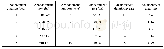
《Table 4 Statistics of abandoned farmland reclamation in Qingyun and Wudi counties of 1993–2017》
 提示:宽带有限、当前游客访问压缩模式
本系列图表出处文件名:随高清版一同展现
《撂荒耕地的提取与分析——以山东省庆云县和无棣县为例(英文)》
The data used in this study include 30 m resolution Landsat images 1990–2011 and2013–2017 from US Geological Survey(USGS)(http://glovis.usgs.gov/) ,with 30 m resolution HJ-1A data obtained from China Resource Satellite Application Center(http://www.cresda.com/CN/)replacing 7 Landsat images of 2012 due to visible stripes in these mages.Time series images for 1990–2017 were collected with 2 images in each year,i.e.56images over 28 years in total.Images were mainly collected for the same two periods each year:April to June and July to October.Table 1 shows specific image details.We also used 30 m resolution DEM data from the spatial data cloud(http://www.gscloud.cn/)as auxiliary data for classification.The 30 m resolution land classification product(1995,2000,2005,2010,2015)from Resource and Environment Data Cloud Platform(http://www.resdc.cn/)and Google Earth images were used as basic data to select training and validation samples.
| 图表编号 | XD0062094400 严禁用于非法目的 |
|---|---|
| 绘制时间 | 2019.04.01 |
| 作者 | 肖国峰、朱秀芳、侯陈瑶、夏兴生 |
| 绘制单位 | Key Laboratory of Environmental Change and Natural Disaster of Ministry of Education,Faculty of Geographical Science,Beijing Normal University、State Key Laboratory of Earth Surface Processes and Resource Ecology,Beijing Normal University、Beijing Engineeri |
| 更多格式 | 高清、无水印(增值服务) |
