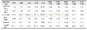
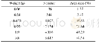
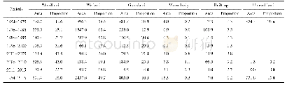
《Table 5 Area ratios and change rates of different land use types in Yarkant River basin(1978–2018)(
 提示:宽带有限、当前游客访问压缩模式
本系列图表出处文件名:随高清版一同展现
《1978–2018年叶尔羌河流域土地利用及其生态服务价值变化数据研究》
Table 5 indicates that significant LUCC occurred in the study area over the 41 years considered here,especially after 2008,and the rate of change became significantly faster.From1978 to 2018,the rate of increase in land use was most pronounced for wetland(249.13%),followed by cultivated land(63.51%),water body(20.35%),forest land(7.02%),unused land(6.82%),and grassland(2.01%).The proportion of cultivated land increased very obviously in this period,with an average annual increase of 8.5×10³ hm2.The other notable change in land use type concerns unused land,which decreased by 227.43×10³ hm2 during the 41 years.Moreover,the areas of a water body and grassland decreased by 103.2×10³ hm2and 59.2×10³ hm2,respectively,while wetlands and woodland increased by 42.7×10³ hm2and 8.2×10³ hm2,respectively.
| 图表编号 | XD00153337600 严禁用于非法目的 |
|---|---|
| 绘制时间 | 2020.03.25 |
| 作者 | 王建平、阿依努尔·买买提、马元旭 |
| 绘制单位 | 中国科学院空天信息创新研究院喀什卫星地面站、中国科学院空天信息创新研究院喀什卫星地面站、中国科学院空天信息创新研究院数字地球重点实验室 |
| 更多格式 | 高清、无水印(增值服务) |