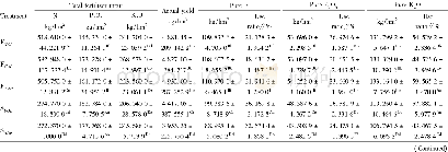
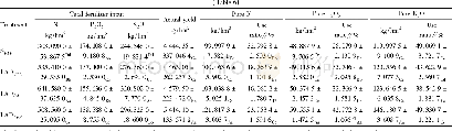
《Table 2 Characteristics of the 30 m×6 m runoff plots used to study the effects of land use and soil
 提示:宽带有限、当前游客访问压缩模式
本系列图表出处文件名:随高清版一同展现
《Efficiency of soil and water conservation practices in different agro-ecological environments in the Upper Blue Nile Basin of Ethiopia》
Note:CL,cultivated land;DB,degraded bush;AD,Acacia decurrens plantation;EP,Eucalyptus spp.plantation;GR,grazing land;1 and2 followed the land use types means gentle slope and steep slope,respectively.0 indicates no soil and water conservation structu
We established experimental runoff plots to represent the different land use and cover types and different slope gradients at three experimental sites(Fig.1):the Guder and Aba Gerima watersheds from the Fagita Lekoma(10°57′–11°11′N,36°40′–37°05′E)and Bahir Dar Zuria(11°25′–11°55′N,37°04′–37°39′E)districts,respectively,of the Amhara Region,and the Dibatie watershed from the Dibatie District(10°01′–10°53′N,36°04′–36°26′E)of the Benishangul Gumuz Region.These sites were selected to represent three important agro-ecology systems in the Upper Blue Nile Basin having different annual precipitation,elevation,experiences with soil and water conservation,soil erosion rates,and land use types(Tables 1 and 2).
| 图表编号 | XD0020359100 严禁用于非法目的 |
|---|---|
| 绘制时间 | 2018.04.01 |
| 作者 | Dagnenet SULTAN、Atsushi TSUNEKAWA、Nigussie HAREGEWEYN、Enyew ADGO、Mitsuru TSUBO、Derege T MESHESHA、Tsugiyuki MASUNAGA、Dagnachew AKLOG、Ayele A FENTA、Kindiye EBABU |
| 绘制单位 | The United Graduate School of Agricultural Sciences, Tottori University、School of Civil and Water Resource Engineering, Institute of Technology, Bahir Dar University、Arid Land Research Center, Tottori University、International Platform for Dryland Research |
| 更多格式 | 高清、无水印(增值服务) |

