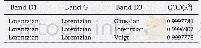
《Table 1 The proportion (and number) of forest plots from three river gorges assigned to different v
 提示:宽带有限、当前游客访问压缩模式
本系列图表出处文件名:随高清版一同展现
《Using classification assignment rules to assess land-use change impacts on forest biodiversity at local-to-national scales》
Vegetation alliances are as defined by Wiser et al.(2011)and Wiser and De Cáceres(2013).The value for the gorge where the alliance was most frequent is indicated in bold.Alliances are ordered by descending frequency in the Mokihinui lower gorge,Mokih
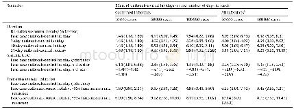
Across the Mokihinui and Karamea lower gorges a total of seven alliances defined by the national classification were observed(Table 1,Fig.3a).The most common alliance in the lower gorge of Karamea was Weinmannia racemosa–Cyathea smithii forest(A:BBl PF3;44%of plots),similar to its high frequency in the Mokihinui lower gorge.One alliance,the Cyathea dealbata–Melicytus ramiflorus forest(A:Bl PF4),was only recorded from the Mokihinui lower gorge,where it was uncommon.Three alliances,Lophozonia menziesii–Weinmannia racemosa forest(A:BBl F3),Fuscospora truncata–Weinmannia racemosa forest(A:BF6),and Beilschmiedia tawa–Weinmannia racemosa forest(A:Bl PF3),were present in the Karamea lower gorge but absent from the Mokihinui lower gorge.Three alliances,Weinmannia racemosa–Cyathea smithii forest(A:BBl PF3),Weinmannia racemosa–Prumnopitys ferruginea forest(A:Bl PF1),and Melicytus ramiflorus–Cyathea smithii forest(A:Bl PF2),were present in both Mokihinui and Karamea lower gorges(Table 1).
| 图表编号 | XD003826000 严禁用于非法目的 |
|---|---|
| 绘制时间 | 2018.06.01 |
| 作者 | Kathrin Affeld、Susan K.Wiser、Ian J.Payton、Miquel De Cáceres |
| 绘制单位 | Manaaki Whenua-Landcare Research、Lincoln University、Manaaki Whenua-Landcare Research、Manaaki Whenua-Landcare Research、Forest Science Centre of Catalonia |
| 更多格式 | 高清、无水印(增值服务) |