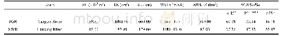
《Table 3 Main features of the Xiaowan Reservoir and the Three Gorges Reservoir》
 提示:宽带有限、当前游客访问压缩模式
本系列图表出处文件名:随高清版一同展现
《Distribution and Susceptibility Assessment of Collapses and Landslides in the Riparian Zone of the Xiaowan Reservoir》
Notes:the capital letters of SC,TA,BL,WLFs,AWLFZ and WDPS represent the storage capacity,total area,backwater length,water level fluctuations,the area of the water-level-fluctuating zone(WLFZ),and WLFZ distribution proportion in different slope
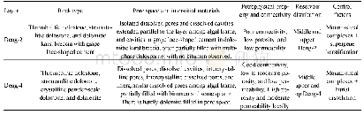
The riparian zone in mega reservoirs have attracted increasing attention since the formation of the WLFZ in the Three Gorges Reservoir(TGR)in China.As the largest hydropower project in the world,after TGR full implementation in 2008,an artificial riparian region with a vertical elevation difference of 30 m and a total area of 349 km2 have been created(Fu et al.2010;Ye et al.2011;Tang et al.2014).At present,research on the environment impact of the WLFZ is still concentrated primarily in the TGR,due to its large area of WLFZ and severe ecological and environmental degradation(Zhou et al.,2010;Li et al.,2013;Wang et al.,2014;Tang et al.,2016;Su et al.,2017).Compared with the TGR,the XWR area,reservoir capacity and the backwater length are on a much smaller scale,even though the water level variation range of 60 m in the XWR is twice that of the TGR(Table 3).Obviously,the difference in area of WLFZ is closely related to the bank topography.The submerged zone of the TGR has a mass of sloping fields,paddy fields,homesteads and other gentle slopes,and thus over 62.00%area of the WLFZ is less than 15°,while the area ratio of steep slope is only 14.58%(Yuan et al.,2013).In contrast,the WLFZ with a gentle slope in the XWR account for less than a third of its total area,whereas the proportion of steep slope area is more than50%(Table 3).In addition,the bank in the TGR is dominated by a soil type with a mixture of soil and rock in the west of Fengjie County,while the bank structure in the east of Fengjie is mainly rock(Bao et al.,2015).Compared to the TGR,the riparian zone of the XWR is composite of a mixture of soil,rock and rock-soil,with a large amount of loose deposits(Li,2011).
| 图表编号 | XD0046956600 严禁用于非法目的 |
|---|---|
| 绘制时间 | 2019.02.01 |
| 作者 | ZHONG Ronghua、HE Daming、HU Jinming、DUAN Xingwu、HUANG Jiangcheng、CHENG Xupeng |
| 绘制单位 | Institute of International Rivers and Eco-security, Yunnan University、Yunnan Key Laboratory of International Rivers and Transboundary Eco-security, Yunnan University、Institute of International Rivers and Eco-security, Yunnan University、Yunnan Key Laborato |
| 更多格式 | 高清、无水印(增值服务) |
