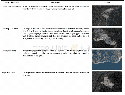
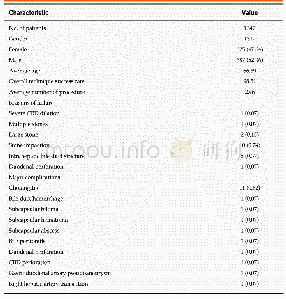
《Table 1 The image characteristics of bank failure and landslide》
 提示:宽带有限、当前游客访问压缩模式
本系列图表出处文件名:随高清版一同展现
《Distribution and Susceptibility Assessment of Collapses and Landslides in the Riparian Zone of the Xiaowan Reservoir》
Meanwhile,the GF-1 and Google Earth images along the XWR were used to investigate the CLs occurring in the riparian zone.The CLs masses were identified using the image features exhibited in Table 1 and checked with the actual CLs data from the field investigation of bank erosion from May to June in 2015 and2016.It is important to note that the CLs investigated in the present study include the masses whose backscarps were located upland of the WLFZ but whose fronts were in the riparian zone(Fig.3).
| 图表编号 | XD0046956500 严禁用于非法目的 |
|---|---|
| 绘制时间 | 2019.02.01 |
| 作者 | ZHONG Ronghua、HE Daming、HU Jinming、DUAN Xingwu、HUANG Jiangcheng、CHENG Xupeng |
| 绘制单位 | Institute of International Rivers and Eco-security, Yunnan University、Yunnan Key Laboratory of International Rivers and Transboundary Eco-security, Yunnan University、Institute of International Rivers and Eco-security, Yunnan University、Yunnan Key Laborato |
| 更多格式 | 高清、无水印(增值服务) |