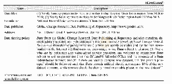
《Table 1 Metedata summary of housing price quarterly change dataset in Nanjing townhouse(apartment,r
 提示:宽带有限、当前游客访问压缩模式
本系列图表出处文件名:随高清版一同展现
《南京城区住宅小区房价变化地理信息数据集(2009-2017)》
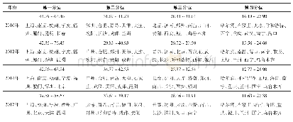
Owing to the compact distribution of the old residential areas and the luxury gated communities in the main city,and mixed distribution of urban villages,temporary dwellings,and newly constructed apartment communities on the outskirts of the city,suburban economic housing communities may be located close to the luxury villa district,which causes fragmentation and discontinuity of inner-urban house prices and is represented as“spatial heterogeneity”,which is more common in the western world[11–12].Due to the significant spatial heterogeneity and discontinuity of house prices in Nanjing,we tried to show original house prices and avoid using spatial interpolation technology to estimate and possibly inflate prices;thus,we utilized Fishnet in ArcGIS to analyze the spatial patterns of commercial residential building prices in the main city of Nanjing.The steps were as follows:(1)Determining the evaluation unit.Based on inner-urban social space characteristics,previous research[13],and earlier test,we set the urban house price evaluation unit as 500 m×500 m,and divided Nanjing main city into such evaluation units using the Fishnet tool in ArcGIS10.2;(2)Spatial data processing for evaluation indicators.By utilizing the Spatial Join tool in ArcGIS10.2,we matched the mean house price value of residential areas in each grid to their corresponding grid attribute value.
| 图表编号 | XD0027634800 严禁用于非法目的 |
|---|---|
| 绘制时间 | 2018.06.25 |
| 作者 | 尹上岗、马志飞、宋伟轩 |
| 绘制单位 | 南京师范大学地理科学学院、江苏省地理信息资源开发与利用协同创新中心、南京师范大学地理科学学院、江苏省地理信息资源开发与利用协同创新中心、中国科学院南京地理与湖泊研究所流域地理学重点实验室 |
| 更多格式 | 高清、无水印(增值服务) |
查看“Table 1 Metedata summary of housing price quarterly change dataset in Nanjing townhouse(apartment,resident community)lev”的人还看了
-
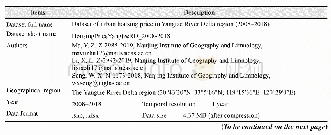
- Table 1 Metadata summary of“Dataset of urban housing price in Yangtze River Delta region(2008–2018)”

