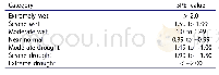
《Table 3 Map Layer Contents Summary by Categories》
 提示:宽带有限、当前游客访问压缩模式
本系列图表出处文件名:随高清版一同展现
《城市地下空间资源综合利用实践——以成都市地质环境图集(2017)数据集为例》
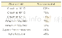
Benchmarks were set by taking multi-phase remote sensing images and results of the third national land survey as basic layers of the maps.The various materials collected were corrected to ensure the overlapping accuracy of the maps.The.shp files collated were all reviewed and then inserted into the database by utilizing the database function of ArcGIS.In this way,the database was developed.
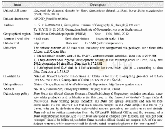
| 图表编号 | XD00149434800 严禁用于非法目的 |
|---|---|
| 绘制时间 | 2019.12.01 |
| 作者 | 王东辉、倪化勇、李鹏岳、郝明 |
| 绘制单位 | 中国地质调查局成都地质调查中心、中国地质调查局成都地质调查中心、中国地质调查局成都地质调查中心、中国地质调查局成都地质调查中心 |
| 更多格式 | 高清、无水印(增值服务) |
