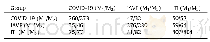
《Table 1Confusion matrix for the 2017 global land cover map, FROM-GLC10, obtained from Sentinel-2 da
 提示:宽带有限、当前游客访问压缩模式
本系列图表出处文件名:随高清版一同展现
《Stable classication with limited sample: transferring a 30-m resolution sample set collected in 2015 to mapping 10-m resolution global land cover in 2017》
a) Overall accuracy = 72.76%,CR = cropland,FR = forest,GR = grassland,SR = shrubland,WE = wetland,WB = water body,TU = tundra,IA = impervious area,BL = bare land,SI = snow/ice,UA = user’s accuracy and PA = producer’s accuracy.
Since its launch in 2015,Sentinel-2 acquires data in 13 spectral bands including four 10-m resolution visible and near infrared bands,six 20-m resolution red-edge and middle infrared spectral bands,and three additional bands measuring atmospheric conditions.We used all but the atmospheric bands.After tests and adjustment,Sentinel-2 acquired more images covering the world in 2017.Therefore,we used 2017 data in mapping 10-m global land cover.To extend the samples for use in 10-m resolution Sentinel-2 images,we used the center of each sample location to match the nearest locations of the Sentinel data to extract and construct spectral features.Elevation data from Shuttle Radar Topographic Mission(SRTM)were also used as ancillary data(https://doi.org/10.1029/2005RG000183).Theinputfeatures include the spectral values of the greenest time in each year,the0,25,50,75 and 100 percentile of time series,and indices of vegetation,water,building and snow as above mentioned in classify-ing Landsa-8 data.Slope and aspect data extracted from the SRTM elevation data are also included in the feature set.In addition,the geographical coordinates including the longitude and latitude are also used.The 10 classes in the first level classification scheme used in Gong et al.[1]has been used except the cloud category(Table 1).A random forest classifier had been used with 200 trees.Other parameters in the algorithm were optimized through a grid searching method.This algorithm has its merit for robustness,high efficiency and high accuracy outcome in processing high dimensional data[5,6].It had been extensively tested in our previous global land cover mapping efforts[4,7].
| 图表编号 | XD0036052000 严禁用于非法目的 |
|---|---|
| 绘制时间 | 2019.03.30 |
| 作者 | Peng Gong、Han Liu、Meinan Zhang、Congcong Li、Jie Wang、Huabing Huang、Nicholas Clinton、Luyan Ji、Wenyu Li、Yuqi Bai、Bin Chen、Bing Xu、Zhiliang Zhu、Cui Yuan、Hoi Ping Suen、Jing Guo、Nan Xu、Weijia Li、Yuanyuan Zhao、Jun Yang、Chaoqing Yu、Xi Wang、Haohuan Fu、Le Yu、Iryna |
| 绘制单位 | Ministry of Education Key Laboratory for Earth System Modeling, Department of Earth System Science, Tsinghua University、AI for Earth Lab, Cross-Strait Institute, Tsinghua University、Ministry of Education Key Laboratory for Earth System Modeling, Departmen |
| 更多格式 | 高清、无水印(增值服务) |