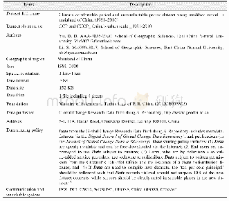
《Table 1 Metadata summary of the land cover dataset within 40 km from coastline along the Straits of
 提示:宽带有限、当前游客访问压缩模式
本系列图表出处文件名:随高清版一同展现
《马六甲海峡两岸土地覆被变化数据集(1990-2017)》
Where mir represents the mid-infrared band;and nir is the near infrared band.
| 图表编号 | XD0027639400 严禁用于非法目的 |
|---|---|
| 绘制时间 | 2018.12.24 |
| 作者 | 王梦涵、闫金凤、张宵宵、高珊珊、徐美荣 |
| 绘制单位 | 山东科技大学测绘科学与工程学院、山东科技大学测绘科学与工程学院、山东科技大学测绘科学与工程学院、山东科技大学测绘科学与工程学院、山东科技大学测绘科学与工程学院 |
| 更多格式 | 高清、无水印(增值服务) |
