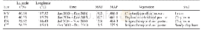
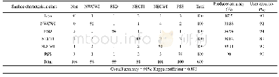
《Table 1.Summary of the surface characteristics at the four validation sites.》
 提示:宽带有限、当前游客访问压缩模式
本系列图表出处文件名:随高清版一同展现
《Subdaily to Seasonal Change of Surface Energy and Water Flux of the Haihe River Basin in China: Noah and Noah-MP Assessment》
Notes:MY,Miyun;HL,Huailai;DX,Daxing;GT,Guantao;MAT,mean annual temperature(C);MAP,mean annual precipitation(mm).
The HRB is a semi-humid and semi-arid transitional region of China(Fig.1).This region covers about 318 000km2,accounting for 3.3%of the national land area.With more than 10%of the national population in this region,including Beijing,Tianjin,and some other megacities,it has become one of the most densely populated areas of the world(Liu et al.,2013).The northern and western basin is dominated by mountains,accounting for about 60%of the whole domain,while the eastern and southeastern part is mainly distributed on the North China Plain.The annual average temperature ranges from 9.2?C to 13.5?C,and the total annual precipitation exceeds 400 mm,being spatial heterogeneous and concentrated in June to September(Table 1).With agricultural production generating a high water demand under the conditions of rapid economic development,over 12%of the satellite-detected increase in evapotranspiration can be attributed to human-induced activities in the region(Pan et al.,2017).Ultimately,investigating the water resources and analyzing the surface energy balance in this basin are important and urgent research topics.
| 图表编号 | XD0030265300 严禁用于非法目的 |
|---|---|
| 绘制时间 | 2019.01.10 |
| 作者 | Fuqiang YANG、Li DAN、Jing PENG、Xiujing YANG、Yueyue LI、Dongdong GAO |
| 绘制单位 | Key Laboratory of Regional Climate-Environment for Temperate East Asia,Institute of Atmospheric Physics,Chinese Academy of Sciences、University of Chinese Academy of Sciences、Key Laboratory of Regional Climate-Environment for Temperate East Asia,Institute |
| 更多格式 | 高清、无水印(增值服务) |