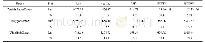
《Table 5 Surface characteristic classification results in terms of total area and percentage of the
 提示:宽带有限、当前游客访问压缩模式
本系列图表出处文件名:随高清版一同展现
《"Remote Sensing Monitoring of Surface Characteristics in the Badain Jaran, Tengger, and Ulan Buh Deserts of China"》
Notes:Non:not sand dune;NWCWI:northwest-southeast coarse sand dune with wide interdune;FSD:fine sand dune;NECTI:northeast-southwest coarse sand dune with thin interdune;NECWI:northeast-southwest coarse sand dune with wide interdune;PSS:potential sand sour
In 2015,the TCA values were below zero in about99.2%,90.6%,and 92.0%of all pixels in the BJD,TD,and UBD respectively,indicating a high ratio of non-vegetated to vegetated area in all three deserts but especially in the BJD.The DI value histograms were similar for the TD and the UBD,with more than 70%of DI values being greater than 4.0.In contrast,the DI value was only greater than 4.0 in 16%of pixels for the BJD,indicating that NECWI and NECTI areas dominate the BJD.TGSI values were greater than 0.26 in about11.0%,60.2%,and 11.5%of pixels in the BJD,TD,and UBD,respectively,indicating that areas with FSDs dominate the TD.Base on Table 1,the mean TCA value was the lowest in the BJD and the highest in the TD.However,the BJD had the smallest range of TCA values,indicating the consistency of the ratio of non-vegetated to vegetated areas in the BJD.The maximum TCA value of 0.441 was observed in the UBD,indicating that it was the most vegetated.The DI standard deviations and ranges were similar between the TD and UBD,where they were greater than those in the BJD,indicating that surface characteristics are quite heterogeneous in the TD and UBD.The range and coefficient of variance in the TGSI value were the greatest in the UBD,indicating the large spatial variance of grain size components in the UBD.
| 图表编号 | XD0046959200 严禁用于非法目的 |
|---|---|
| 绘制时间 | 2019.02.01 |
| 作者 | LIU Qingsheng、LIU Gaohuan、HUANG Chong、LI He |
| 绘制单位 | State Key Laboratory of Resources and Environmental Information System, Institute of Geographic Sciences and Natural Resources Research, Chinese Academy of Sciences、Jiangsu Center for Collaborative Innovation in Geographical Information Resource Developme |
| 更多格式 | 高清、无水印(增值服务) |


