《Table 2 Geographic position information of 25 sampling points in 10/2011(Excerpt)》
 提示:宽带有限、当前游客访问压缩模式
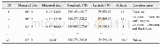
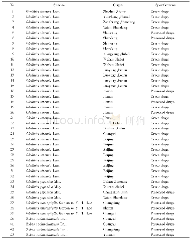
There were 3 times water quality sampling and synchronized water spectra measurements[5–6]in October 2011,July 2012 and October 2012.Geographical location and altitude information of the corresponding sampling sites are shown in the data file(1),(3)and(5).Table 2 shows the geographical location and altitude information of the 25 sampling points measured in October,2011(Excerpt).
| 图表编号 | XD0027618100 严禁用于非法目的 |
|---|---|
| 绘制时间 | 2017.06.29 |
| 作者 | 王卷乐、张永杰、杨飞、曹晓明、柏中强、祝俊祥、陈二洋、李一凡、冉盈盈 |
| 绘制单位 | 中国科学院地理科学与资源研究所资源与环境信息系统国家重点实验室、中国科学院地理科学与资源研究所资源与环境信息系统国家重点实验室、中国科学院地理科学与资源研究所资源与环境信息系统国家重点实验室、中国林业科学研究院荒漠化研究所、中国科学院地理科学与资源研究所资源与环境信息系统国家重点实验室、中国科学院大学、中国科学院地理科学与资源研究所资源与环境信息系统国家重点实验室、中国科学院大学、中国科学院地理科学与资源研究所资源与环境信息系统国家重点实验室、中国矿业大学、中国科学院地理科学与资源研究所资源与环境信息系统 |
| 更多格式 | 高清、无水印(增值服务) |