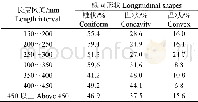
《Table 2 Mushroom boulders’shape elements》
 提示:宽带有限、当前游客访问压缩模式
本系列图表出处文件名:随高清版一同展现
《"Origin of the Mushroom Stone Forest at the southeastern foot of the Little Sangpu Mountain in eastern Guangdong,China: A palaeo-sea-level indicator or not"》
Notes:CA=concavity apex of sidewall;MD=Maximum Depth;dir=direction;alt=altitude;MS=mushroom Stone;dia=diameter;L=Long diameter;S=short diameter.
Apart from mushroom-shaped boulder 12,which is located on the hillside of the Little Sanpu Mountain at an altitude of 14.33 m(13.77 m above Pearl River Datum),the remaining mushroomshaped boulders are situated at the southeastern foot of the Little Sangpu Mountain with elevations ranging from 0.84 to 7.42 m above sea level(Pearl River Datum)(Table 2) .The\""Anvil Stone\"",which as its name suggests,looks like an anvil,is an iconic feature that attracts many local tourists.It is located on a mountainous ridge at approximately93 m above sea level(Pearl River Datum).The\""Anvil Stone\""is a big boulder of about 10 m high that perches on another boulder(Figure 2h-1).
| 图表编号 | XD0056559400 严禁用于非法目的 |
|---|---|
| 绘制时间 | 2019.03.01 |
| 作者 | LI Jian-cheng、WANG Wei、ZHENG Yan-ming |
| 绘制单位 | Geography department of Hanshan Normal University、Geographic school of South China Normal University、Geography department of Hanshan Normal University |
| 更多格式 | 高清、无水印(增值服务) |

