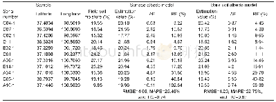
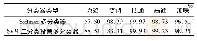
《Table 1 Comparison of accuracy from two estimation models1)》
 提示:宽带有限、当前游客访问压缩模式
本系列图表出处文件名:随高清版一同展现
《Remotely sensed estimation and mapping of soil moisture by eliminating the effect of vegetation cover》
1) AE,RE,RMSE,MAPE and TIC refer to absolute error,relative error,root mean square error,mean absolute percent error and theil inequality coefficient,respectively.
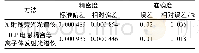
Using the soil type map,the statistical characteristics of SM were obtained for different soil types through spatial statistical analysis(Table 2).Histosols soil is located in the low-lying belts of river sources,mountains,valleys and lake plains.Naturally,its SM is the highest,with an average value of 21.7%,minimum value of 12.9%,and maximum value of 75.8%.Inceptisols is mainly distributed in the relatively flat plateau-planation surface which is beneficial to collect and preserve SM.Therefore,its SM is relatively high,with an average of 20.9%.Aridisols is located in the edge of small basin depressions.This terrain is also useful for stopping water from flowing away,but there is strong evaporation,causing soil salinity to gradually accumulate to land surface,leading to decreasing SM.So,taken together,the SM of Aridisols is relatively high.SM estimation results,at an average value of 21.1%,were reasonable.Mollisols is developed in semi-humid cold climatic region,and is mainly distributed in the lake terraces,with vegetation of alpine grassland.Therefore,its SM is relatively small,with an average value of 20.5%and a minimum value of 1.2%.Entisols is mainly distributed in mountain ridges,moraine terrace,and flowstone beach,and is filled with a large amount of gravel resulting in strong water permeability.Therefore,its SM is the minimum,with the average value of 19.4%.Overall,SM estimation results were consistent with the characteristics of soil types and terrain in Qinghai Lake Basin.
| 图表编号 | XD0047431300 严禁用于非法目的 |
|---|---|
| 绘制时间 | 2019.02.20 |
| 作者 | WU Cheng-yong、CAO Guang-chao、CHEN Ke-long、E Chong-yi、MAO Ya-hui、ZHAO Shuang-kai、WANG Qi、SU Xiao-yi、WEI Ya-lan |
| 绘制单位 | College of Geographical Sciences, Qinghai Normal University、Key Laboratory of Environment and Ecology of Qinghai-Tibet Plateau, Ministry of Education、Qinghai Key Laboratory of Natural Geography and Environmental Processes、Key Laboratory of Environment and |
| 更多格式 | 高清、无水印(增值服务) |
