《Table 1 Eight ground reference classes of Washington DC data[15]》
![《Table 1 Eight ground reference classes of Washington DC data[15]》](http://bookimg.mtoou.info/tubiao/gif/GJST201804006_07500.gif) 提示:宽带有限、当前游客访问压缩模式
提示:宽带有限、当前游客访问压缩模式
本系列图表出处文件名:随高清版一同展现
《D-SS Frame: deep spectral-spatial feature extraction and fusion for classification of panchromatic and multispectral images》
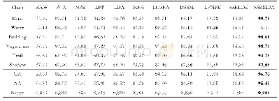
The first data set Washington DC,USA,was acquired with the WorldView-2 satellite on February 9th,2016.As shown in Fig.2,the dataset analyzed is available with 8 spectral bands and spatial resolution0.4 m for panchromatic and 1.6 m for multispectral.The dimension of the MS and PAN images used for the processing is 2 438×896 pixels.The ground reference data constructed by visual inspection(photointerpretation),GIS tools and helped by Open Street Map(OSM),consist of 8 classes of interest as described in Table 1.
| 图表编号 | XD0020606500 严禁用于非法目的 |
|---|---|
| 绘制时间 | 2018.12.01 |
| 作者 | Teffahi Hanane、Yao Hongxun |
| 绘制单位 | School of Computer Science and Technology,Harbin Institute of Technology、Algerian Space Agency、School of Computer Science and Technology,Harbin Institute of Technology |
| 更多格式 | 高清、无水印(增值服务) |


