《Table 1 Status of land use within two kilometers of the Yichun-Wanzai Expressway》
 提示:宽带有限、当前游客访问压缩模式
本系列图表出处文件名:随高清版一同展现
《Land Use Analysis of Yichun-Wanzai Expressway》
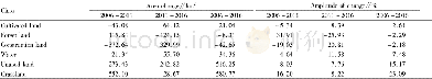
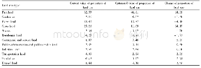
Based on the land use planning of Yuanzhou District and the land use planning of Wanzai County,the status of land use within the planned scope is clarified(Table 1).The total planned land area is 220.26 km2.The core area of the Yichun-Wanzai Economic Corridor covers an area of 3 142.95 km2.The planned area has reached 7%.Most of the land used for the current situation is forest land and cultivated land.The area of forest land and basic farmland is 100.18 and 53.28 km2,respectively.The proportion of forest land and basic farmland reaches 69.7%of the total planned area.Urban land and industrial land are relatively small.The two types of land only account for 6.2%of the total land use,and they are mainly concentrated in the eastern part of Yuanzhou District and southeast of Wanzai County.
| 图表编号 | XD00182651100 严禁用于非法目的 |
|---|---|
| 绘制时间 | 2018.12.01 |
| 作者 | Hongchun GUO、Wei WU、Xiying HU |
| 绘制单位 | College of Urban Construction,Jiangxi Normal University、College of Urban Construction,Jiangxi Normal University、College of Urban Construction,Jiangxi Normal University |
| 更多格式 | 高清、无水印(增值服务) |
