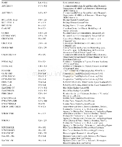
《Table 1.Details of the 34 CMIP5 CGCMs used in this study.》
 提示:宽带有限、当前游客访问压缩模式
本系列图表出处文件名:随高清版一同展现
《Meridional Displacement of the East Asian Upper-tropospheric Westerly Jet and Its Relationship with the East Asian Summer Rainfall in CMIP5 Simulations》
In this study,we used historical simulations from 34CMIP5 CGCMs,which are forced by the observed history of greenhouse gases,aerosol concentrations,solar radiation volcanic eruptions,and other climate forcings(all-forcing experiment;Taylor et al.,2012).Some of the models have more than one ensemble member available and only Run 1from each model was used.To compare the models’simulations at the same horizontal resolution,we interpolated monthly mean variables,including precipitation and horizontal wind,into a regular grid of 2.5°×2.5°by the bilinear interpolation method.The period from 1900 to 2005 was used to examine the interannual variation.We also examined the period from 1979 to 2005,and the main results were similar.Table 1 lists the main information of these models,includ-zontal wind was obtained from the National Centers for Environmental Prediction–Department of Energy Reanalysis-2 datasets().The precipitation came from the Global Precipitation Climatology Project().The horizontal resolutions were 2.5°in longitude and latitude and the period spanned 38 years from 1979 to 2016.Some other datasets,including the Climate Prediction Center Merged Analysis Precipitation()and ERA-Interim(),were also examined and showed similar results.
| 图表编号 | XD0086020300 严禁用于非法目的 |
|---|---|
| 绘制时间 | 2019.11.10 |
| 作者 | Yuhan YAN、Chaofan LI、Riyu LU |
| 绘制单位 | State Key Laboratory of Numerical Modeling for Atmospheric Sciences and Geophysical Fluid Dynamics,Institute of Atmospheric Physics, Chinese Academy of Sciences、College of Earth and Planetary Sciences, University of the Chinese Academy of Sciences、Center |
| 更多格式 | 高清、无水印(增值服务) |
![Table 2 List of the Landsat data[22]used in this study](http://bookimg.mtoou.info/tubiao/gif/QQSJ201804005_29300.gif)

