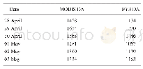
《Table 2 Summary of satellite imageries》
 提示:宽带有限、当前游客访问压缩模式
本系列图表出处文件名:随高清版一同展现
《珠穆朗玛峰山麓三个典型冰川湖泊变化数据集内容与研发》
Since the satellite imageries merely present the digital number(DN),it was needed to convert to the top of atmosphere(TOA)reflectance in order to calculate the NDWI which was conducted using reflectance data.Different time period data used different resolution.
| 图表编号 | XD0027612600 严禁用于非法目的 |
|---|---|
| 绘制时间 | 2017.03.25 |
| 作者 | 陈文波、福井弘道、土光智子、刘闯、冯强、勾鹏、石瑞香 |
| 绘制单位 | 日本庆应义塾大学SFC研究所、日本中部高等学術研究所、日本庆应义塾大学SFC研究所、中国科学院地理科学与资源研究所资源与环境信息系统国家重点实验室、中国科学院遥感与数字地球研究所、中国科学院青藏高原研究所、中国科学院地理科学与资源研究所资源与环境信息系统国家重点实验室 |
| 更多格式 | 高清、无水印(增值服务) |


