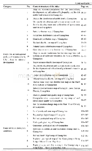
《Table 2 Structure of Chapters and Contents of the Atlas》
 提示:宽带有限、当前游客访问压缩模式
本系列图表出处文件名:随高清版一同展现
《支撑服务广州市规划建设与绿色发展资源环境图集数据集》
All maps in the Atlas were prepared in the Map GIS format,and are therefore convenient for inquiry and strongly editable,features a clear mathematical basis and can be overlapped and merged with data of the same type and reprocessed.Furthermore,it is convenient for dataset management and information sharing.Therefore,the Atlas can satisfy the demand of professionals for any relevant application and research and provide important references for the compilation of relevant atlases used to provide supports and service.The Atlas,boasting strong integration,flexible expression means,rich content and high legibility,has been submitted to local governments and the associated departments for use.In this way,it has provided an important foundation for the building of a“transparent Nanshan”,the construction of sponge cities and the planning of national land space in Guangzhou,thus supporting and serving the strategic needs of national development.
| 图表编号 | XD00149448400 严禁用于非法目的 |
|---|---|
| 绘制时间 | 2019.12.01 |
| 作者 | 刘凤梅、黄长生、赵信文 |
| 绘制单位 | 中国地质调查局武汉地质调查中心、中国地质调查局武汉地质调查中心、中国地质调查局武汉地质调查中心 |
| 更多格式 | 高清、无水印(增值服务) |


