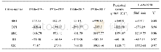
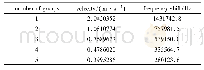
《Table 4 Cross-sections wise channel centerline shifting prediction using linear regression method,
 提示:宽带有限、当前游客访问压缩模式
本系列图表出处文件名:随高清版一同展现
《印度西孟加拉邦帕吉勒提河的河道形态和曲流带迁移基数波动评估(英文)》
The time period for this study is 238 years,which has been separated into two,qualitative(1779 to 1968)and quantitative(1968 to 2017).All quantitative measurements have been done from 1968 to 2017.The topographical map from the Survey of India(SOI)has been considered as the base map.The river course has been identified from the orthorectified satellite imagery of Landsat-5(TM)of 1987(8,December),1995(28,January),2005(7,January)and LISS-IV satellite imagery(2017,5 January)along with SOI Toposheet of1968–1969(79A/2,79A/3,79A/6 and 79A/7)and Rennell’s map(1779)and digitized using ArcGIS 10.3 software and subsequently saved as a Geodatabase files(Table 1).
| 图表编号 | XD0062095700 严禁用于非法目的 |
|---|---|
| 绘制时间 | 2019.04.01 |
| 作者 | Rakhohori Bag、Ismail Mondal、Jatisankar Bandyopadhyay |
| 绘制单位 | Department of Remote Sensing & GIS,Vidyasagar University、Department of Marine Science,University of Calcutta、Department of Remote Sensing & GIS,Vidyasagar University |
| 更多格式 | 高清、无水印(增值服务) |

