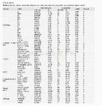
《Table 4 Spatial relation of conditioning factors and landslides using landslide numerical risk fact
 提示:宽带有限、当前游客访问压缩模式
本系列图表出处文件名:随高清版一同展现
《GIS-based landslide susceptibility mapping using numerical risk factor bivariate model and its ensemble with linear multivariate regression and boosted regression tree algorithms》
Investigating the effect of each class of factor on landslide occurrence using the LNRF method(Table 4)showed that for the elevation parameter,class 343-824 m(LNRF 1.58)had the strongest correlation with landslides,and its effect decreased with increasing elevation.However,the frequency of landslides increased with elevation.Conditionsare favourable for landslides in the study area,due to the presence of deep soils at low elevations and the influence of human factors in mountainous downstream areas.Our results are consistent with previous findings by Pourghasemi and Rossi(2016).
| 图表编号 | XD0056564900 严禁用于非法目的 |
|---|---|
| 绘制时间 | 2019.03.01 |
| 作者 | Alireza ARABAMERI、Biswajeet PRADHAN、Khalil REZAE、Masoud SOHRABI、Zahra KALANTARI |
| 绘制单位 | Department of Geomorphology,Tarbiat Modares University、Centre for Advanced Modelling and Geospatial Information Systems (CAMGIS),Faculty of Engineering and IT,University of Technology Sydney、Department of Energy and Mineral Resources Engineering,Choongmu- |
| 更多格式 | 高清、无水印(增值服务) |

