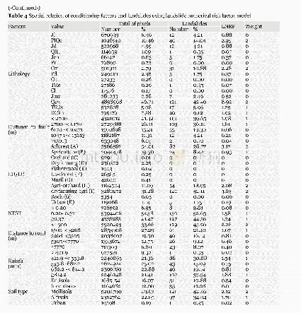
《Table 2 Overview of factors used for landslide susceptibility mapping》
 提示:宽带有限、当前游客访问压缩模式
本系列图表出处文件名:随高清版一同展现
《GIS-based landslide susceptibility mapping using numerical risk factor bivariate model and its ensemble with linear multivariate regression and boosted regression tree algorithms》
After detailed surveys of 1:100,000-scale geological maps,satellite images and 1:40,000-scale aerial photographs and field survey data,the geological map of the study area was prepared(Figure 3i).Table 1 describes the lithology units.ETM+2002 satellite data obtained from the Soil Conservation Section of the Agricultural and Natural Resources Research Centre of Isfahan Province were used in the software ENVI4.7 to produce a fault map of the Gorganroud watershed(Figure 3j).Distance to fault was calculated using distance tools in ArcGIS.After extracting the faults,their maps were prepared in five classes in ArcGIS10.5.Landsat 8 image(Path 162/Row 34)was used to prepare land use(Figure 3k)and NDVI(Normalized difference vegetation index)(Figure 3l) and the maps of the study area in ENVI4.7.Supervised classification(maximum likelihood)was used to prepare an LU/LC map.A total of 645ground control points were used for validation using Kappa index.The Kappa coefficient for the prepared map was 0.955,which indicates high accuracy.
| 图表编号 | XD0056564800 严禁用于非法目的 |
|---|---|
| 绘制时间 | 2019.03.01 |
| 作者 | Alireza ARABAMERI、Biswajeet PRADHAN、Khalil REZAE、Masoud SOHRABI、Zahra KALANTARI |
| 绘制单位 | Department of Geomorphology,Tarbiat Modares University、Centre for Advanced Modelling and Geospatial Information Systems (CAMGIS),Faculty of Engineering and IT,University of Technology Sydney、Department of Energy and Mineral Resources Engineering,Choongmu- |
| 更多格式 | 高清、无水印(增值服务) |

