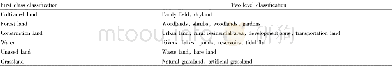
《Table 1 The environmental predictors used in the machine learning methodologies》
 提示:宽带有限、当前游客访问压缩模式
本系列图表出处文件名:随高清版一同展现
《Modelling and mapping soil erosion potential in China》
1) DEM,digital elevation model;MrVBF,multi resolution index of valley bottom flatness;NDVI,the normalized difference vegetation index;NPP,net primary productivity;SOC,soil organic carbon.2) SRTM,Shuttle Radar Topography Mission;CMA,China Meteorologi
In addition,geographically weighted regression(GWR)(Xu et al.2015;Ma et al.2017) was applied to downscale R factor to 1-km spatial resolution.Some key steps were described in Ma et al.(2017)and Teng et al.(2017).The environmental variables,including terrain attributes,climatic variables,vegetation and soil(Table 1),were chosen in the downscaling procedure.
| 图表编号 | XD0047429400 严禁用于非法目的 |
|---|---|
| 绘制时间 | 2019.02.20 |
| 作者 | TENG Hong-fen、HU Jie、ZHOU Yue、ZHOU Lian-qing、SHI Zhou |
| 绘制单位 | College of Environmental and Resource Sciences, Zhejiang University、State Key Laboratory of Soil and Sustainable Agriculture, Chinese Academy of Sciences、College of Environmental and Resource Sciences, Zhejiang University、College of Environmental and Reso |
| 更多格式 | 高清、无水印(增值服务) |