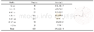
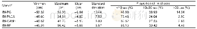
《Table 4 Statistics of refugee camp》
 提示:宽带有限、当前游客访问压缩模式
本系列图表出处文件名:随高清版一同展现
《海地地震(2010)遥感分析速报联合国数据集的研发》
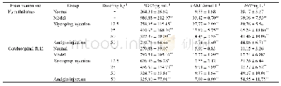
After an earthquake effective and timely investigation of direct damages from disasters is very crucial.Remote sensing techniques were proved to be useful in detecting,identifying and monitoring the impact and effect of earthquake.Through acquiring,processing,interpreting and analyzing remote sensing data,the ARC/GIS datasets of damaged buildings,road network,refugee camps and related report on disaster were presented to UN-SPIDER and UNPAN by UN GAID e-SDDC within several days after the earthquake,which will provide help to them to make rapidly decisions on the routes for rescue and disaster relief dispatch.
| 图表编号 | XD0027616500 严禁用于非法目的 |
|---|---|
| 绘制时间 | 2017.06.29 |
| 作者 | 刘闯、郭华东、吕婷婷、王晋年、刘定生、王世新、顾行发、曲国胜 |
| 绘制单位 | 中国科学院地理科学与资源研究所、中国科学院遥感与数字地球研究所、中国科学院遥感与数字地球研究所、中国科学院遥感与数字地球研究所、中国科学院遥感与数字地球研究所、中国科学院遥感与数字地球研究所、中国科学院遥感与数字地球研究所、中国地震应急搜救中心 |
| 更多格式 | 高清、无水印(增值服务) |
