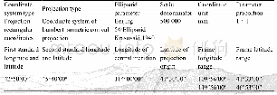
《Table 1 Parameters of grids in the nested domains》
 提示:宽带有限、当前游客访问压缩模式
本系列图表出处文件名:随高清版一同展现
《Numerical simulation of the climate effect of high-altitude lakes on the Tibetan Plateau》
In the triple-nested domains(Figure 1),the outermost nested domain included the TP and its surrounding region;and the third one(d03)included Ngoring Lake and the surrounding region.The parameters of the nested domains are listed in Table 1.The high-resolution simulation with the 2-km grid spacing in the innermost nested domain can describe the influence of heterogeneity in the terrain and lake depth on the simulation.The simulation experiments began on May 1,2011 and ended on October 1,2012(Universal Time Coordinated);and the simulation results were output every three hours for the d03 domain.In this study,the ERA-Interim reanalysis data with1.0°spatial and 6-h temporal resolution,were employed as the initial fields and lateral boundary conditions for the outermost domain.The model was divided into 30 layers and topped at the 50-hPa level in the vertical direction.Other model parameters included the Noah land-surface model(Chen and Dudhia,2001),the WSM6 microphysical scheme(Hong and Lim,2006),the RRTMG long-wave and shortwave radiation schemes(Clough et al.,2005),the MM5 similarity surface-layer scheme,and the ACM2boundary-layer scheme(Pleim,2007).The KainFritsch cumulus scheme(Kain,2004)is used only in the outermost(d01)and intermediate(d02)nested domains because the cumulus scheme is used mainly for coarser grid sizes(Skamarock et al.,2005).In finescale simulations,the convection may be resolved by the grid;and thus a cumulus scheme may no longer be needed(Nasrollahi et al.,2012).Li and Pu(2009)demonstrated that using a cumulus scheme at a 9-km grid size improved the simulation results,while this scheme had a small impact on the result at a 3-km grid size.
| 图表编号 | XD0023781900 严禁用于非法目的 |
|---|---|
| 绘制时间 | 2018.10.01 |
| 作者 | YinHuan Ao、ShiHua Lyu、ZhaoGuo Li、LiJuan Wen、Lin Zhao |
| 绘制单位 | Key Laboratory of Land Surface Process and Climate Change in Cold and Arid Regions, Northwest Institute of Eco-Environment and Resources, Chinese Academy of Sciences、Plateau Atmosphere and Environment Key Laboratory of Sichuan Province, School of Atmosphe |
| 更多格式 | 高清、无水印(增值服务) |
