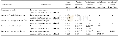
《Table 3.Statistical analysis of the difference between simulated and measured rainfall.》
 提示:宽带有限、当前游客访问压缩模式
本系列图表出处文件名:随高清版一同展现
《Improved Land Use and Leaf Area Index Enhances WRF-3DVAR Satellite Radiance Assimilation: A Case Study Focusing on Rainfall Simulation in the Shule River Basin during July 2013》
Figure 8 shows the cumulative rainfall distribution from the four WRF experiments and two observational datasets,CPDG and CMCPHG,from the China Meteorological Administration.The cumulative rainfall in the CPDG dataset was concentrated mainly in the eastern Shule River Basin(Fig.8a),and the precipitation intensity in the CMCPHG dataset was greater in the western part of the domain(Fig.8b).Meanwhile,the WRF simulation experiments showed subtler orographic features,such as high precipitation along the southern high-altitude mountain area(Figs.8c–f),the characteristics of which could not be represented well by the interpolated observations,especially CPDG,with coarser grids.Compared with gauge data from 43 sites,the WRF simulation experiments represented the spatial distribution of precipitation better(R2>0.4;Table 3)than the CPDG dataset(R2=0.38;Fig.S8 in the ESM).Previous research demonstrates that coarse-grid observational data may be unreliable in some unpopulated regions(Ji and Kang,2013;Ji et al.,2016).Among the simulation experiments,the rainfall area in CTRL(Fig.8c)was similar to that in MODS(Fig.8d),but the precipitation intensity in MODS was much lower than that in CTRL.In the western portion of the region,the precipitation intensity was lower in TONG(Fig.8e)and TOUN(Fig.8f)than in CTRL or MODS.Moreover,compared with TONG,the precipitation intensity and area clearly varied in TOUN as a result of the updated land use and leaf area index data.
| 图表编号 | XD0015819400 严禁用于非法目的 |
|---|---|
| 绘制时间 | 2018.06.10 |
| 作者 | Junhua YANG、Zhenming JI、Deliang CHEN、Shichang KANG、Congshen FU、Keqin DUAN、Miaogen SHEN |
| 绘制单位 | State Key Laboratory of Cryospheric Sciences, Northwest Institute of Eco-Environment and Resources,Chinese Academy of Sciences (CAS)、School of Atmospheric Sciences, Sun Yat-sen University、Department of Earth Sciences, University of Gothenburg、State Key La |
| 更多格式 | 高清、无水印(增值服务) |


