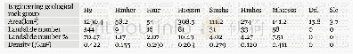
《Table 4 Number of landslides in different engineering geological rock group》
 提示:宽带有限、当前游客访问压缩模式
本系列图表出处文件名:随高清版一同展现
《"Landslide integrated characteristics and susceptibility assessment in Rongxian county of Guangxi,China"》
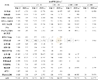
The landslide inventory map generated by Arc GIS10.2(Figure 1)is derived from continuous field investigations during 2004~2013 with a scale of 1:50000,analysis of topographic maps and aerial photographs,and historical records of landslides.Nearly a decade of field surveys in study area was strictly complied with the investigation standard of landslide and debris flow(No DD2008-02)set by China geological survey(China Geological Survey2008).According to this standard,the areas having the environment of landslide formation are identified as the focus of the field investigation through the interpretation of aerial photographs.Theyincludetowns,villagesettlements,infrastructures(roads and bridges),mines and reservoirs.After identifying the landslide,a subsequent detailed investigation is conducted on a scale of 1 50000.Thus,these surveyed data can basically represent the landslide status in study area In this research,a total of 772 landslides are located in study area,and the scales of most landslides are small(Table 1).
| 图表编号 | XD0056569500 严禁用于非法目的 |
|---|---|
| 绘制时间 | 2019.03.01 |
| 作者 | LIAO Li-ping、ZHU Ying-yan、ZHAO Yan-lin、WEN Hai-tao、YANG Yun-chuan、CHEN Li-hua、MA Shao-kun、XU Ying-zi |
| 绘制单位 | College of Civil Engineering and Architecture,Guangxi University、Key Laboratory of Disaster Prevention and Structural Safety of Ministry of Education,Guangxi University、Guangxi Key Laboratory of Disaster Prevention and Engineering Safety,Guangxi Universit |
| 更多格式 | 高清、无水印(增值服务) |


