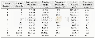
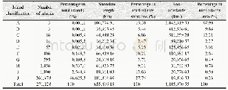
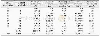
《Table 1 Study area extent, pixel size and number of landslides (see also Figure 1) .》
 提示:宽带有限、当前游客访问压缩模式
本系列图表出处文件名:随高清版一同展现
《Landslide susceptibility: a statistically-based assessment on a depositional pyroclastic ramp》
The topographic variables of this study relate to two DEMs of varying quality.The coarser scaled DEM(i.e.15 m)was constructed by using photogrammetric techniques(INEGI 2013a)whereas the higher resolved DEM(i.e.5 m)was based on an aerial Li DAR campaign(flight on January 20,2010)(INEGI 2013b) .Two different study area delineations(Larger L and smaller S)were defined because only the 15 m DEM covers the entire study area(Figure 1).In detail,the entire study area extends over 163 km2(region L15)while the sub-region covers 70.3 km2(region S5).Summarizing,region L is larger and region S represent a sub-region of L(Figure 1).Data set L15relates to the 163 km2large region,662 mapped landslides and a DEM resolution of 15 m.The data set S5 relates to the mentioned sub-region(70.3km2),449 landslides and the 5 m DEM(Table 1)The third data set,namely S15,covers the same extension as region S5(70.3 km2),but is based on a coarser DEM resolution(i.e.15 m).
| 图表编号 | XD0056564300 严禁用于非法目的 |
|---|---|
| 绘制时间 | 2019.03.01 |
| 作者 | Franny G.MURILLO-GARCíA、Stefan STEGER、Irasema ALCáNTARA-AYALA |
| 绘制单位 | Institute of Geography,National Autonomous University of Mexico (UNAM)、Institute for Earth Observation,Eurac Research、Institute of Geography,National Autonomous University of Mexico (UNAM) |
| 更多格式 | 高清、无水印(增值服务) |