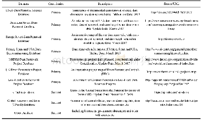
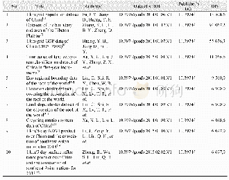
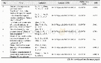
《Table 1 List of the major datasets of global dam removal》
 提示:宽带有限、当前游客访问压缩模式
本系列图表出处文件名:随高清版一同展现
《Global Trends in Dam Removal and Related Research: A Systematic Review Based on Associated Datasets and Bibliometric Analysis》
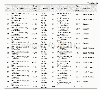
Note:USGS:The United States Geological Survey,USA:The United States of America,NHDES:New Hampshire Department of Environmental Services,UK:The United Kingdom
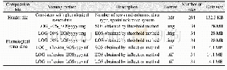
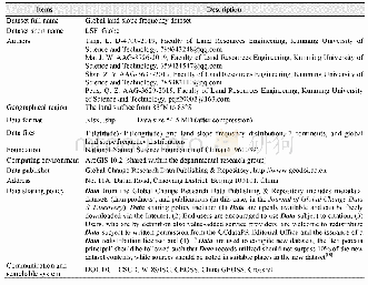
In this study,nine datasets on dam removal were collected(Table 1):the United States Geological Survey(USGS)Dam Removal Science Database(2015);American Rivers Dam Removal Database(2016);European Rivers Dam Removal Database(2016);The United Kingdom River Restoration Project Database;Low-Head Dam Removal Project Database;France,Spain and United States Dam Decommissioning Database;and other dam removal project databases.Due to the multiple sources of data and various geographic coordinate systems used(e.g.,WGS1972,WGS1984 and NAD1983),the spatial location of each removed dam was corrected by consistently using the Robinson(world)Coordinate System.When location information was missing,we searched Google EarthTM,the Global Reservoir and Dam(GRanD)database and the literature to identify the location of the dam.Additionally,other supplemental information was used to supply missing attributes.Still,some of the basic information(i.e.,the date of the dam removal)could not be determined.Attributes included the name of the dam(alternative name),name of the impounded river,name of the main basin,name of the nearest city,height of the dam in metres,age of the dam in years,latitude/longitude,and year(not further specified:year of construction;year of completion;year of decommissioning).Moreover,a global polygon layer,basic metadata information and projection information were provided in ESRI shapefile format with accompanying XML(.shp.xml)and ASCII(.prj)files.Each shapefile consists of five core files(.dbf,.sbn,.sbx,.shp,and.shx files).The above information was integrated to map the distribution of dam removal using ArcGIS 10.4.1.
| 图表编号 | XD0046955100 严禁用于非法目的 |
|---|---|
| 绘制时间 | 2019.02.01 |
| 作者 | DING Liuyong、CHEN Liqiang、DING Chengzhi、TAO Juan |
| 绘制单位 | Yunnan Key Laboratory of International Rivers and Transboundary Eco-security, Yunnan University、Institute of International Rivers and Eco-security, Yunnan University、Yunnan Key Laboratory of International Rivers and Transboundary Eco-security, Yunnan Univ |
| 更多格式 | 高清、无水印(增值服务) |