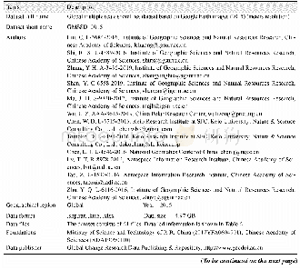
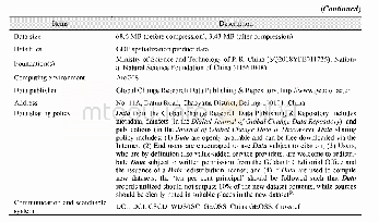
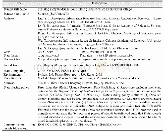
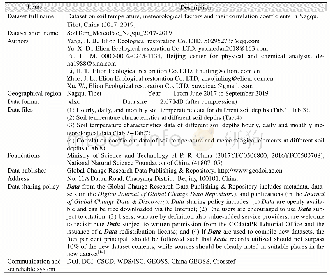
《Table 1 Metadata summary of the“Global multiple scale shorelines dataset based on Google Earth imag
 提示:宽带有限、当前游客访问压缩模式
本系列图表出处文件名:随高清版一同展现
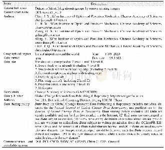
《2015年全球岛(礁)有多少陆地面积及海岸线长几何——基于Google Earth遥感影像的数据结果》
The“Global multiple scale shorelines dataset based on Google Earth images(2015)”[10]consists of a series of data with spatial resolution of meters(less than 10 m),30 m,250 m,1 km,10 km,and 20 km.Thecurrent study only discusses the data with resolution in meters.The summary of the metadata is shown in Table 1.
| 图表编号 | XD00110314400 严禁用于非法目的 |
|---|---|
| 绘制时间 | 2019.06.25 |
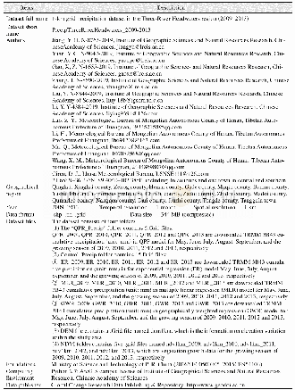
| 作者 | 刘闯、石瑞香、张应华、申艳、马军花、吴立宗、陈文波、Tomoko Doko、陈利军、吕婷婷、陶醉、诸云强 |
| 绘制单位 | 中国科学院地理科学与资源研究所、中国科学院地理科学与资源研究所、中国科学院地理科学与资源研究所、中国科学院地理科学与资源研究所、中国科学院地理科学与资源研究所、中国极地研究中心、日本庆应义塾大学SFC研究所、日本自然与科学咨询公司、日本庆应义塾大学SFC研究所、日本自然与科学咨询公司、国家基础地理信息中心、中国科学院空天信息研究院、中国科学院空天信息研究院、中国科学院地理科学与资源研究所 |
| 更多格式 | 高清、无水印(增值服务) |