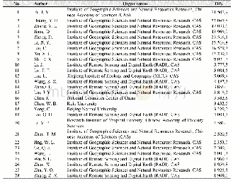
《Table 1 List of GlobeLand30_ATS2010 dataset authors》
 提示:宽带有限、当前游客访问压缩模式
本系列图表出处文件名:随高清版一同展现
《全球30 m分辨率人造地表覆盖数据集(2010)的内容与研发》
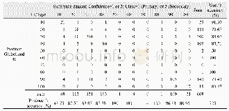
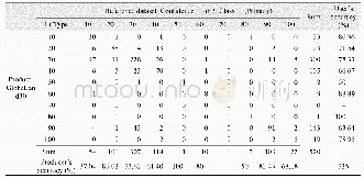
Most urban area covers resident places,roads,green spaces and water bodies,which is a mosaic structure.In this case,the water body belongs to the land surface waters type and the green space belongs to the forest or grassland,thus the artificial land surface only covers resident places and roads.The industrial and mining land use type includes open-cast mine area,salt field and auxiliary road and building facilities.The minimum mapping unit for planar pattern is 4×4 pixels.Linear pattern spots mainly include railways,highways and other lands for transportation,and the minimum mapping unit for linear pattern is 1×6 pixels.
| 图表编号 | XD0027614700 严禁用于非法目的 |
|---|---|
| 绘制时间 | 2017.06.29 |
| 作者 | 陈军、廖安平、陈利军、张宏伟、何超英、彭舒、武昊、张委伟、李然、郑新燕、梅洋、陆苗、鲁楠、康睿、邢华侨、刘丽芬、韩刚、王京、杨爱玲、孙丽梅、宋昊、陈卫平、周晓敏、夏露、蒋红兵、霍健、张艳、刘无敌、李雨鲜、翟亮、桑会勇 |
| 绘制单位 | 国家基础地理信息中心、国家基础地理信息中心、国家基础地理信息中心、国家基础地理信息中心、国家基础地理信息中心、国家基础地理信息中心、国家基础地理信息中心、国家基础地理信息中心、国家基础地理信息中心、国家基础地理信息中心、国家基础地理信息中心、国家基础地理信息中心、国家基础地理信息中心、国家基础地理信息中心、国家基础地理信息中心、国家基础地理信息中心、国信司南北京地理信息技术有限公司、国家基础地理信息中心、国信司南北京地理信息技术有限公司、国信司南北京地理信息技术有限公司、黑龙江基础地理信息中心、黑龙江基础 |
| 更多格式 | 高清、无水印(增值服务) |

